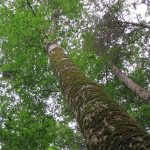
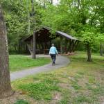
Weymouth Woods Sandhills Nature Preserve
Renovations at Catawba Falls allow public access to the beautiful upper falls.
Carolina Outdoors Guide – Parks & Forests – Camping – Hiking – Adventures


There are about 1.25 million acres of National Forest Service land in North Carolina, with a great majority open to the public for wide-ranging recreation. In addition to campgrounds in all four national forests in the state, the forests have day-use areas (below: Croatan, Nantahala, Pisgah, Uwharrie) available for sight-seeing, fishing, picnicking, swimming and other activities.
Several day use areas require fees for entry or for specific uses, such as to reserve picnic shelters. National Forest picnic shelters seat 24 to 44 people. If picnic shelters have not been reserved, their use is free.
The national forests have also set aside backcountry and wilderness areas, such as the Linville Gorge Wilderness area, known for its hiking and rock climbing opportunities, and the lesser-known Birkhead Mountains Wilderness in the Uwharrie National Forest.
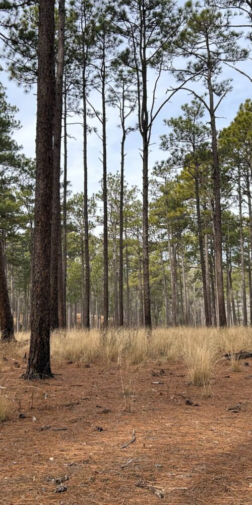
The mountains’ national forests are home to several beautiful waterfalls, including the 411-foot Whitewater Falls, the tallest falls east of the Rockies. The Croatan National Forest, on the coast, offers several opportunities for easy hiking on flat terrain through pine forests, saltwater estuaries, bogs and raised swamps, or “pocosins.”
Below, we have information about day use areas in each forest and contact information for each forest ranger district (the larger Nantahala and Pisgah forests each have multiple ranger districts). Look for more information about North Carolina’s national forests on the Hiking and Camping pages.
After destructive storms, check at the links below to make sure sites are open.
This is the headquarters office:
Forest Supervisor’s Office
National Forests in North Carolina
160 Zillicoa Street, Suite A
Asheville, NC 28801
(828) 257-4200
Online contact form
Locator Map
Go to Nantahala, Pisgah or Uwharrie national forest.
Updated May 2025.
Croatan National Forest
141 E. Fisher Avenue
New Bern, NC 28560
(252) 638-5628
sm.fs.croatan@usda.gov
Locator Map
Forest Recreation Map
Croatan Day Use Areas
– Black Swamp OHV Trails, near Maysville. Eight miles of trails designated for all-terrain vehicles, trail bikes and four-wheel drives with a wheel base of less than 50 inches. Daily fee is $5, season pass is $30. Permits are available at the trailhead, the district office and local stores.
 – Brice’s Creek, near New Bern. Boat launch for non-motorized boats on Brice’s Creek, with fishing and picnic area. No fee. The Brice’s Creek Trail is the starting point of the Croatan’s Saltwater Adventure Trail, a paddler’s 100-mile, seven-day, almost-circumnavigation of the forest via water.
– Cahooque Creek Boat Launch, near Havelock. Non-motorized boat access to Cahooque Creek for fishing, kayaking, etc. No fee.
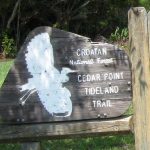
– Cedar Point Recreation Area, near Swansboro. A salt-water marsh and coastal forest near the mouth of the White Oak River with the Tideland National Recreation Trail, fishing, boat ramp, camping, picnicking, toilets. (252) 638-5628. Click on the photo above-right for more information.
– Haywood Landing, near Maysville. Boat launch for non motorized boat access to the White Oak River for fishing, kayaking, etc. No fee.
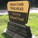 – Island Creek Trail, near Pollocksville. Half-mile interpretive trail through rich botanical area provides opportunity to view large and small wildlife. Click on the photo at right for more information.
 – Neuse River Recreation Area, near New Bern. Offers the Flanners Beach swimming area with cold-shower bathhouse, trails for hikers and bikers, camping, picnicking, flush toilets. (252) 638-5628. Click on the photo at left for more information.
– Patsy Pond Nature Trail, between Cedar Point and Morehead City. The interpretive trail through an open woodland of longleaf pines with low growing herbs and shrubs has .75-mile, 1-mile and 1.9-mile loops.
 – Pine Cliff Equestrian Trails, near Havelock. The combined Foster, Jones and Wright trails provide 13 miles of bridle path.
– Pine Cliff Picnic Area, near Havelock. The small site on the Neuse River has a picnic shelter, vault toilet, water and opportunity for fishing and hiking, including a trailhead for the 20-mile Neusiok Trail. Click on the photo at right for more information.
Go to Camping in Croatan National Forest for several more day use sites/campgrounds.
Cheoah Ranger District
1070 Massey Branch Road
Robbinsville, NC 28771
(828) 479-6431
sm.fs.cheoahrd@usda.gov
Locator Map
Nantahala Ranger District
90 Sloan Road
Franklin, NC 28734
(828) 524-6441
sm.fs.nantahalard@usda.gov
Locator Map
Tusquitee Ranger District
123 Woodland Drive
Murphy, NC 28906
(828) 837-5152
sm.fs.tusquiteerd@usda.gov
Locator Map
Forest Recreation Map (includes Pisgah National Forest)
Nantahala Day Use Areas
– Arrowood Glade, near Franklin. Roadside picnic site off of U.S. 64 on Wayah Road (SR1310) has picnic tables, a picnic shelter, grills, drinking water and flush toilets. Near Wayah Bald. Open April 1 – October 31.
 – Balsam Lake and Picnic Area, near Tuckasegee. Offers fishing and walking trail along Wolf Creek and eight-acre lake, picnicking, drinking water and vault toilets. No water or restrooms in winter. Overlooking the lake, Balsam Lake Lodge, with 16 twin beds, three bathrooms and a fully equipped kitchen, can be rented by groups. Phone (828) 524-6441 or visit Recreation.gov for lodge rental. Click on the photo at right for more information.
 – Bridal Veil Falls, near Highlands. A short side road off of U.S. 64 allows you to drive behind the waters of 120-foot Bridal Veil Falls. Click on the photo at left for more information.
– Cheoah Point Recreation Area, near Robbinsville. Open April 15 to October 31; boat launch open year-rond. Includes a swimming beach on Santeetlah Lake, fishing, camping, boat ramp, picnicking (handicapped accessible; shelter), drinking water and flush toilets (handicapped accessible) and trails.
– Cherohala Skyway, near Robbinsville. 43-mile National Scenic Byway along the crest of the Smoky Mountains, includes the Tail of the Dragon, a top motorcycle ride. The area also offers also overlooks, picnicking, trails and vault toilets. See also Cherohala.com.
– Cliffside Lake, near Highlands. Open April 1 to October 31. Swimming and bathhouse with cold showers; fishing; six short trails, some leading to waterfalls; two picnic shelters (can be reserved); drinking water, flush toilets. Fee charged. Adjacent to Van Hook Glade Campground.
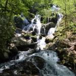
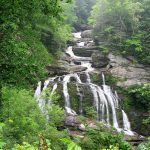 – Cullasaja Gorge, between Franklin and Highlands is access via a narrow, winding 7.5-mile drive on U.S. 64. Includes Bridal Veil Falls just west of Highlands (above); 75-foot Dry Falls (below); Cullasaja Falls, a 250-foot cascade near the foot of the gorge; and nearby Upper Cullasaja Falls. Click on the photo for more information.
–Dirty John Shooting Range, near Franklin. Six firing lanes or stations on a 100-yard range with target frames set at 25, 50 and 100 yards. Stationary paper targets or manufactured silhouette targets only. Vault toilet. Fee charged.
–Dry Falls, near Highlands. A short, accessible walkway goes behind the 75-foot Dry Falls. The site has bathrooms, picnic tables and parking. Fee charged.
– Ellicott Rock Wilderness, near Highlands. North Carolina is home to about 3,400 acres of the 8,274-acre wilderness area shared with South Carolina and Georgia. The steep terrain offers hiking, primitive camping, fishing, waterfalls and access to South Carolina’s Foothills Trail. The Chattooga River, a National Wild and Scenic River, crosses the wilderness area.
–Ferebee Picnic Area and Launch, near Franklin. Picnic area with tables and charcoal grills, flush toilets. This alternative to main Nantahala River boat launch is about 2.75 miles downriver. April 1 to October 31.
– Fires Creek Recreation Area, near Hayesville. The area is open to trout fishing, hiking, horseback riding, and camping. Fifty-three miles of trails include the 25-mile Rim Trail and a short loop trail to Leatherwood Falls. Camping is available at Bristol Horse Camp and at primitive sites at Huskins Branch Hunters Camp.
 – Glenn Falls, near Highlands. A steep .60-mile trail leads to the three 60-foot drops of Glenn Falls (also spelled “Glen”). Click on the photo at left for more information.
– Hanging Dog Recreation Area, near Murphy on Hiwassee Reservoir. Lake is open to fishing (including from an accessible pier), boating, kayaking, water skiing. The moderately-difficult Ramsey Bluff Mountain Biking System provides 8 miles of trails. Recreation area also has two 1-mile walking trails, a picnic grounds, vault toilets.
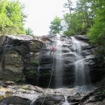
 – Granite City, near Cashiers. Unsanctioned area provides opportunity for bouldering, climbing and rappelling. Click on the photo at right for more information.
– Jackrabbit Mountain Recreation Area, near Hayesville. Open May 1 to September 30. Swimming beach on Chatuge Lake, hot showers, 15 miles of bike trails, 2.4-mile easy loop hiking trail, camping, fishing, boat ramp, boat rentals, picnic shelters, drinking water, flush toilets (handicapped accessible). Fee charged.
 – Joyce Kilmer Memorial Forest, near Robbinsville. A figure-8 2-mile loop courses through a virgin old-growth forest with more than 100 tree species, many over 400-years-old, and some more than 20 feet in circumference and 100 feet tall. Picnicking, flush and vault toilets (handicapped accessible). Click on the photo at left for more information.
– Moss Knob Shooting Range, near Franklin and Highlands. Four firing lanes or stations on a 100-yard range with frame targets set at 7, 25 and 100 yards. Stationary paper targets or manufactured silhouette targets only. Vault toilet. Fee charged. Open year-round.
– Nantahala River Gorge, between Almond and Topton. The area offers 8.5 miles of whitewater rafting, fishing, hiking trails, picnicking, drinking water, flush toilets (handicapped accessible). Fee charged for rafting. Outfitters and guides available onsite for whitewater rafting and fishing.
– Panther Top Shooting Range, near Murphy. Six 100-yard firing lines for rifles and four 25-yard firing lines for pistols; one picnic table with grill. Fee charged. Open year-round. The Mountain Country Rod and Gun Club of Murphy maintains Panther Top. They have directions to the site and other info here.
 – Silver Run Falls, near Cashiers. There is a short, easy crushed-stone trail to the base of the 30-foot falls. Click on the photo at right for more information.
– Standing Indian Picnic Area, near Franklin. Picnicking, drinking water, flush toilets. Open April 1 to November 30. Adjacent to Standing Indian Campground. Fee charged.
–Tsali Recreation Area, near Almond on Fontana Lake. More than 40 miles of trails are open to hiking, biking and horseback riding but are best known as a challenging mountain bike course. Tsali also offers fishing, seasonal hunting, camping, boat ramp, picnicking, drinking water, vault toilets (handicapped accessible). Open year-round; campground open April 15 – October 31.
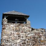 – Wayah Bald, near Franklin. Historic fire tower affords panoramic views. Bartram Trail and Appalachian Trail cross the area. Picnicking, exhibits, vault toilets (handicapped accessible). The 1913 Wilson Lick Ranger Station, first ranger station in the Nantahala National Forest, is nearby. Road closed January 1-April 1. Click the photo at left for more information.
– Whiteside Mountain, near Highlands. Two-mile loop trail climbs above the sheer 750-foot high cliffs to the 4,930-foot summit and outstanding views. The Forest Service r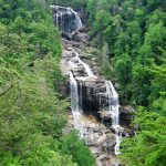 ates the trail “more difficult” because of its steepness. Vault toilets. Fee charged.
– Whitewater Falls, near Cashiers. The 411-foot waterfall is tallest in the East. A short trail to an overlook is wheelchair accessible. Picnicking, drinking water, flush toilets (handicapped accessible). Fee charged. Click on the photo at right for more information.
Go to Camping in Nantahala National Forest for several more day use sites/campgrounds.
Return to Top of National Forests
Appalachian Ranger District
632 Manor Road
Mars Hill, NC 28754
(828) 689-9694
appalachianrd@usda.gov
Locator Map
Grandfather Ranger District
109 E. Lawing Drive
Nebo, NC 28761
(828) 652-2144
sm.fs.gfr@usda.gov
Locator Map
Pisgah Ranger District
1600 Pisgah Highway
Pisgah Forest, NC 28768
(828) 877-3265
sm.fs.pisgahrd@usda.gov
Locator Map
Forest Recreation Map (includes Nantahala National Forest)
Pisgah Day Use Areas
– Brown Mountain OHV Area, near Colletsville. Open April 1 to January 1. 34 miles of trails ranging from easy to difficult for off-highway vehicles, including jeeps and other four-wheeled vehicles on some trails. Primitive camping is also allowed; sites have tables, grills and lantern posts, and there’s a water hydrant and vault toilet at the trailhead. Fee charged.
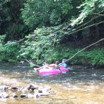
– Carolina Hemlocks Recreation Area, near Burnsville. Open April 20 to October 30. Popular for swimming and tubing on the South Toe River, and tubes are available to rent. Also fishing, trails, picnicking, drinking water, flush toilets. Adjacent to Carolina Hemlocks Campground. Fee charged.
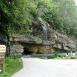
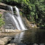
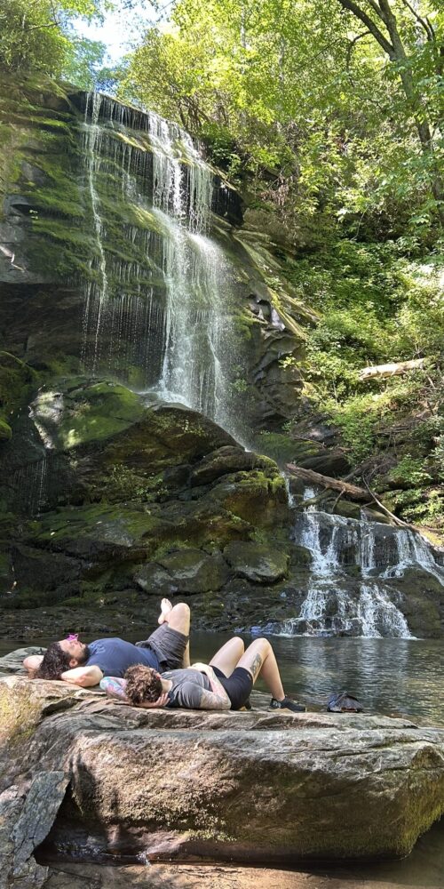
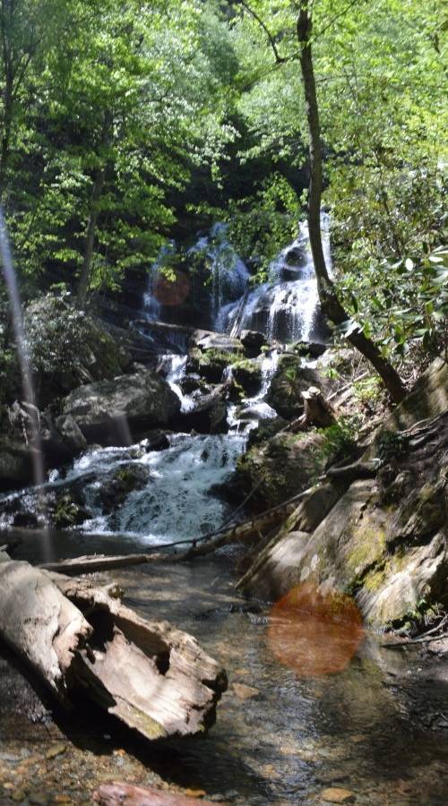
 – Catawba Falls, near Old Fort. A trail and footbridges over the river and Chestnut Branch lead to the 100-foot lower falls, and a series of staircases and a tower provide access to the 50-foot upper falls on the Catawba River. Vault toilets, parking. Click on the photo at right for more information.
– Cold Springs, Harmon Den. 3.6-mile Cold Springs Trail is open hiking and horseback riding and includes a pretty picnic spot with fishing in Cold Spring Creek.
– Cradle of Forestry, near Pisgah Forest (see also FIND Outdooors’ Cradle of Forestry page). Open April 14 to November 4. Two 1-mile interpretive trails, several exhibits and a movie at vistor center, guided hikes, additional organized programs, drinking water, flush toilets (handicapped accessible). Pink Beds Picnic Area is next door. Fee charged.
– Elk River Falls, aka Big Falls, near Elk Park. Half-mile rocky walkway to a 65-foot waterfall.
– Lake Powhatan Recreation Area, near Asheville in the heart of the Bent Creek Experimental Forest, which has an extensive trail system. Includes a large picnic area with 22 tables, a swimming beach with lifeguards in summer, fishing pier (handicapped accessible), drinking water and flush toilets. Adjacent to Lake Powhatan Campground. Fee charged.
– Linville Falls, near Linville Falls community. Short trail leads to overlooks of the double waterfall, as well as views of Linville Gorge (see immediately below). Area connects via trail to Blue Ridge Parkway site with visitors center, restrooms and picnic tables. Vault toilet at site. Click on the photo at right for more information.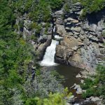
– Linville Gorge Wilderness Area, near Linville Falls community. The 2,000-foot-deep gorge is formed by the Jonas Ridge on the east and Linville Mountain on the west and is bisected by the Linville River. It offers numerous opportunities for hiking, backpacking, rock climbing (permit required), fishing, hunting and primitive camping. A permit is required for camping on weekends and holidays from May 1 through October 31.
– Looking Glass Falls, near Brevard. Observation points are available roadside on U.S. 276 and on a stairway to the pool at the foot of the 60-foot falls, which is popular for swimming.
– Lost Cove, near Burnsville. A 2.5-mile trail offers several views of the Nolichucky River Gorge and leads to the deserted community of Lost Cove and remains of a school, church, grist mill and some homes.
– 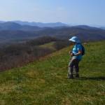 Max Patch, near Hot Springs. Two loop trails of 1.4 and 2.4 miles. Hikers can climb to the grassy summit (elev. 4,629 feet) for 360-degree vistas that include Mount Mitchell to the east and the Great Smoky Mountains to the southwest. The Appalachian Trail crosses the area. Click on the photo at right for more information.
–  Murray Branch Picnic Area, near Hot Springs. Picnic tables and grills, two shelters, two accessible fishing piers, access for rafting or tubing on the French Broad River, and a short loop trail nearby. April 1 to October 31. Click on the photo at leftt for more information.
–North Mills River Picnic Area, near Asheville. Picnic tables on a large picnic area, plus nearby trails open for hiking, biking and horseback riding; fishing (accessible platform), drinking water, flush toilets. Adjacent to North Mills River Campground. Fee charged.
– Pink Beds Picnic Area, near Brevard. 21 picnic tables, 2 shelters on large open field with access to the Pink Beds hiking trail. Drinking water, flush toilets. Adjacent to Cradle of Forestry in America and its Forest Discovery Center. Fee for shelter rental.
– Roan Mountain, near Bakersville. Short trails on mountain ridge known for rhododendron gardens, grassy balds and spruce fir forests. Also picnicking, drinking water, flush toilets (handicapped accessible). Appalachian Trail crosses the area. Open Memorial Day to last Friday morning in September. Fee charged.
– Rocky Bluff Picnic Area, near Hot Springs. Picnic grounds with 10 tables and an amphitheater, plus 1.2-mile loop trail to Spring Creek, a trout-fishing creek. Drinking water and flush toilets. Adjacent to Rocky Bluff Campground.
– Shining Rock Wilderness Area, near Canton. Shining Rock encompasses more than 18,000 acres with elevations varying from 3,300 to over 6,000 feet. There are multiple trails, but they are neither signed nor blazed, and are maintained at a low level. Groups of campers may not be larger than 10 people at any time, and campfires are not allowed. Sunburst Campground, with nine sites near Waynesville, is on the edge of the wilderness area. The wilderness area is named for the white quartz outcropping near the crest of the Shining Rock Mountain (6,040 feet).
– Sliding Rock Recreation Area, near Brevard. Popular 60-foot natural water slide that ends in a 8- to 10-foot-deep pool is open from Memorial Day through Labor Day. Lifeguards on duty in season. One observation platforms. Flush-toilet restrooms, drinking water (water may be shut off when rec area closes). Fee charged.
–  Sycamore Flats Picnic Area, near Brevard. Picnic area on the Davidson River adjacent to Davidson River Campground has a picnic shelter and 40 tables, grills and bathrooms, and a half-mile trail. Access to the river makes it popular for tubing and fishing. Fee for shelter reservation. Click on the photo for more information.
– Table Rock, near Morganton. Short trails along the rim of Linville Gorge to summit of Table Rock and the Chimneys. Also picnicking and vault toilets (handicapped accessible). Open April 1 to December 31. (828) 652-2144.
– Toms Creek Falls, between Marion and Little Switzerland (near Linville Caverns). A half-mile accessible trail leads to an observation deck at the foot of the 80-foot cascade. Off I-40 at U.S. 221 North (exit 85), go 1.2 miles to Huskins Branch Road then to the rght for 1.2 miles to the parking lot and trailhead.
 – Upper Creek Falls, near Jonas Ridge. A steep, 0.4-mile trail leads to series of cascades dropping about 80 feet along the rocky slope. A 0.9-mile trail goes to the bottom of the falls. A 1.6-mile loop requires twice fording the creek by wading or rock-hopping toget to the lower falls.
– Wisemans’ View, near Linville Falls. Short, wheelchair-accessible trail leads to views of Linville Gorge, and Hawksbill and Table Rock mountains. Vault toilets (handicapped accessible). Click on the photo at right for more information.
Go to Camping in Pisgah National Forest for several more day use sites/campgrounds.
Return to Top of National Forests
Uwharrie National Forest
789 Biscoe Road
Troy, NC 27371
(910) 576-6391
uwharrie@fs.fed.us
Locator Map
Forest Recreation Map
Uwharrie Day Use Areas
– Badin Lake Recreation Area, at Badin, comprises the five sites below and four family campgrounds on the 5,350-acre lake, an impoundment of the Yadkin River.
– Badin Lake OHV Trail Complex. 17 miles of trails in four systems in the Badin Lake area of the forest are open April 1 to December 15 for off-highway vehicles. The Art Lilley Campground offers primitive camping among the trails. Trail fees charged (and are required for camping).
– Cove Boat Ramp. Ramp with adjacent swim and fishing areas on Badin Lake, plus access to Badin Lake Trail and vault toilets. (910) 576-6391.
– Flintlock Valley Shooting Range, 1359 Moccasin Creek Road, Troy. Two shelters with covered shooting benches, restroom and parking. The rifle range is 100 yards and the pistol range is 25 yards. Fees charged; passes sold at Forest Service office and Troy Welcome Center, not on site.
– Holt’s Picnic Area. Picnic tables and fire grates on Badin Lake. Fishing, vault toilets.
– Kings Mountain Point. Four handicapped-accessible fishing piers on Badin Lake, an accessible paved trail that circles 34 picnic tables and grills and a picnic pavilion with electricity, water and three grills, which accommodates 50 and can be reserved. Rec area is near a swimming beach, a large play field and access to the Badin Lake Trail. Drinking water, vault toilets. Fee to reserve picnic pavilion.
– Birkhead Mountains Wilderness Area. The 5,160 acres at the northern end of the Uwharrie Mountains have designated hiking trails (horses and vehicles are not allowed), and are available for primitive camping and hunting.
– Wood Run Mountain Bike Trails, between Albemarle and Troy. Includes Wood Run Road (11 miles out and back, and additional half-mile spur), 5-mile Supertree Trail and 6-mile Keyauwee Trail. Wood Run Camp offers primitive camping 1.4 miles from Wood Run Trailhead. On N.C. 24/27, two miles east of the bridges over Lake Tillery/Pee Dee River.
Go to Camping in Uwharrie National Forest for several more day use sites/campgrounds.
Carolina Music Festivals, a calendar and guide to music festivals in North Carolina.
More results...
 Weymouth Woods Sandhills Nature Preserve
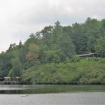
 Catawba Falls, Pisgah National Forest
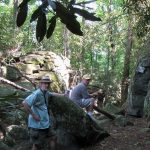
 Raven Rock State Park, Lillington, North Carolina
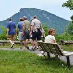
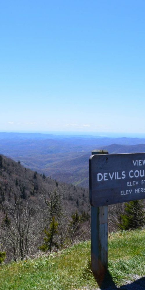 Devil’s Courthouse, Blue Ridge Parkway
 Graveyard Fields & Upper Falls, Blue Ridge Parkway
 Gorges State Park to Offer Family Campground and Cabins
 Catawba Falls Trail Closes for Work Toward Expanded Access
 Mattamuskeet National Wildlife Refuge